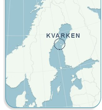
How do I get there? Pictures Description

To the north the landscape becomes steeper, with large open spaces between the islands. Rock formations are not unusual; good examples can be found in Västerö and Jöusan. Västerö is a large island with a permanent residents and road links to the mainland. The hiking trail in the southern part of the island offers historic sites and a varied landscape. Jöusan is northeast of Västerö in the archipelago.

Pohjakartta © Maanmittauslaitos lupanro 172/MYY/02

Jöusan - Västerö

Jöusan

Jöusan is a relatively high island, its northern part in particular is hilly and has flat rock pine forests, while the southern part mainly has young mixed forest on previously clear-cut areas. There are also a few marshes and bogs. The beaches vary with flat rock shelves, rocks and boulders. The inlets have small sand beaches. Jöusan has several ancient ruins such as jungfrudanser (mazes) and Russian ovens.

Jöusan has long been a popular destination by boat. With the exception of one privately-owned holiday home, Jöusan is owned by the state and managed by Metsähallitus.

Västerö

Västerö offers both flat moraines and dramatic rock formations. At Västerö's west beach steep shoreline cliffs rise over 20 metres above sea level. The waters outside are also deep. The place was named Ryssberget, which means "Russian Mountain", after Russian ships crushed against the cliffs during fall storms in 1714. This was also the site where weapons and ammunitions were unloaded for the war of independence in 1917. The vessel that shipped the load was called Equity. In memory of this event a memorial was erected at Storsandviken.

One way to become acquainted with the area is to hike the trail in the southern part of Västerö. This will take you through old forests and over hills, across inlets and along the beach with a view of the open sea. The trail also goes past the Equity memorial. You can choose between both long and short hikes.

Photo: Lise-Lotte Molander
Photo: Eero Murtomäki
The cliffs at Ryssberget, Västerö
Västerö's cliffs in the evening sun
Small lakes and marshes are common on Jöusan and Västerö. Photo from Västerö
     
Photo: Eero Murtomäki
Flat rock pine forest with blooming labrador tea on Jöusan
Old hollow tree trunks provide food and homes for many animals
Compass rose at Jöusan
     
Photo: Eero Murtomäki
The open sea to the west

How do I get there

The Västerö hiking trail is easy to reach by road. Either drive through Maxmo kyrkby (church village) or turn off from national highway 8 in Kaitsor and drive through Hellnäs. The distance from Kaitsor to Västerö is about 26 kilometres. To get to the trailhead turn off the Västerö-Österö road at the sign for Equity. There is parking at Söderskatavägen and at Equityvägen.

The only way to get to Jöusan is by boat. Good places to go ashore are in Västerviken bay on the southwest side of Jöusan.

Pointers

More information about these destinations is available from
Maxmo Hembygdsförening Klemetsgårdarna tel. 06 345 0122 (summer) http://www.klemets.fi/

Skärgårdsläget Varppi, Västerövägen 1587, Västerö, tel. 06 345 5065

The road to Västerö goes through Maxmo archipelago over many bridges in intimate and thickly wooded countryside that is ideal for bicycle trips. At Varppi you can rent bicycles and canoes and also order packed lunches.

Skärgårdsläget Varppi also arranges excursions to Mickelsörarna and Jöusan.

See under Boat Ride and Nature Guides.

Links

Västerö hiking trail (information + map) http://www.klemets.fi/sv/vandringsleder.php (in Swedish)
Vörå-Maxmo municipality www.vora-maxmo.fi (in Swedish)


Texts: Anders Enetjärn, Lise-Lotte Molander.
Translation: Accent Språkservice AB.
Layout & illustrations: Päivi Anttila.
Webbdesign: Fredrik Smeds, Freddi Com Oy Ab.
for maintenance & updates contact: info@kvarken.org.